Last updated
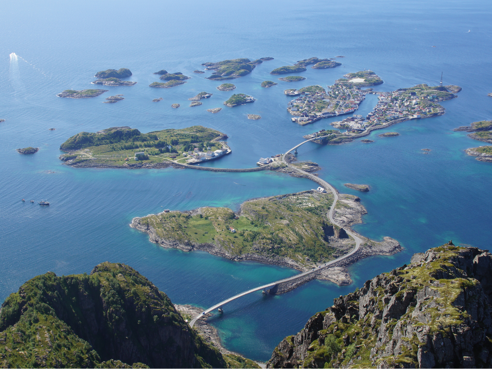
Festvågtind is a 541-metre peak just outside Henningsvær that puts the entire village, its scattered islands, and the Vestfjord directly below you. On a clear day, you can see across to the Norwegian mainland. The hike is short in distance, only about 3 km round trip, but you're gaining over 500 metres of elevation in roughly 1.5 km, so it's steep from the first step. Most people reach the summit in one to two hours and complete the round trip in two to three, though that stretches if you linger halfway up.
The trailhead is on Route 816, about 2 km before the first bridge into Henningsvær. There's a paid car park at Festvåg (marked as "Festvågtind Car Park" on Google Maps, payable by app) and a few free spots further along the road near the bridge at Engøya. All of them fill up fast in July. Get there early morning or push it to late evening. During peak summer, the midnight sun means you can start at 21:00 and hike in full daylight with almost nobody on the trail.
The trail
The first section involves scrambling over and around large boulders. You might see faint arrows painted on the rock, but don't count on clear markings. Multiple informal paths have been worn into the hillside by hikers going off route, and some of them lead nowhere useful or toward the climbing routes on Festvågveggen. Keep heading up through the centre of the gully between the two ridges and you'll find the main trail.
About halfway up, at around 190 metres, you'll reach Heiavatnet, a small mountain lake that makes a natural rest stop. People swim here in summer. The water is cold enough that most of them don't stay in long. Just southwest of the lake, a viewpoint overlooks Henningsvær and the bridges connecting its islands. If the summit feels like too much, this viewpoint is a legitimate destination on its own: similar perspective, a fraction of the effort.
Past the lake, the terrain shifts to loose scree and steeper rock. The trail gets rougher and the footing less predictable, but it never becomes technical climbing. Near the top, you'll need your hands for a short scramble over a few rock steps, maybe 2-3 metres, before reaching the summit plateau. The summit itself is broader than you'd expect from below, with room to walk around and take in views in every direction.
The descent is harder than the climb. Loose gravel on steep ground requires careful footwork even in dry conditions, and after rain the trail gets genuinely treacherous. If it rained that morning, consider postponing.
What to bring
Sturdy hiking boots with aggressive tread. Trail runners won't cut it on the scree and the boulder section at the bottom. Bring water and food. There are no facilities at the trailhead or anywhere on the trail: no toilets, water source, or shelter.
The hiking season runs roughly mid-May through October, depending on snow conditions. Outside that window, the steep terrain makes conditions significantly more demanding. Winter ascents are advised against entirely because of the gradient. Low clouds and sea fog can roll in fast during any season and completely erase the view. Check yr.no before you go. If the summit is socked in, spend your time in Henningsvær instead and come back another day.
Who this hike is for
Festvågtind is a hike for reasonably fit people who don't mind sustained steep terrain and uneven footing. It's not a family walk with small children (though the lake at Heiavatnet works well as a turnaround point for families with older kids). If steep descents on loose ground sound miserable, the coastal paths around Henningsvær village offer a completely different experience without the physical toll.
For photographers, the summit puts Henningsvær's island cluster directly below you, with ocean and mountains layered behind it. Late evening light in summer rakes across the islands at a low angle, and if you're here during midnight sun season, you can time the hike to catch it without worrying about a dark descent.
More than 28,000 people hiked Festvågtind in a recent year, and in July it shows. Bodies moving slowly on a narrow, steep path create bottlenecks, and the car parks overflow. June and early September are better months if you have flexibility. The weather is less predictable in September, but the trail is noticeably quieter and the light turns golden earlier in the evening.
Highlights
Best time to go
Time needed
Getting there
Hotels nearby